Fichier:Bahn-Streckenkarte Deutschland-06-2010.png

Fichier d’origine (1 122 × 1 515 pixels, taille du fichier : 680 Kio, type MIME : image/png)
| Ce fichier et sa description proviennent de Wikimedia Commons. | Accéder au fichier sur Commons |
| Description |
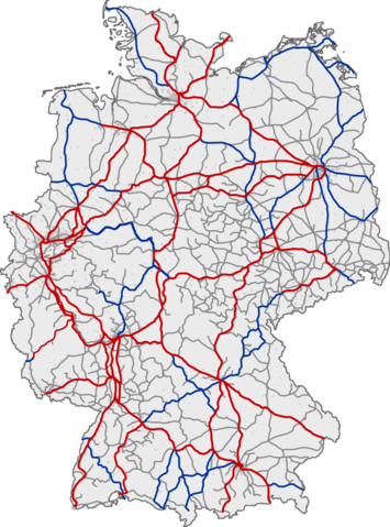
Deutsch: Eisenbahnnetz in Deutschland. Rot: ICE-Strecken; blau: IC/EC-Strecken; grau: sonstiger Personenverkehr
English: Railway network of Germany. Red: lines with InterCityExpress traffic; blue: lines with InterCity/EuroCity traffic; grey: lines with other passenger traffic
Français : Réseau ferré allemand. Rouge : lignes InterCityExpress (ICE); bleu : lignes InterCity/EuroCity; gris : autres lignes de transport de passagers
Magyar: Németország vasúthálózata ;vörös :Vasútvonal InterCityExpress közlekedéssel ;kék :Vasútvonal InterCity/EuroCity közlekedéssel ;szürke :Vasútvonal egyéb személyvonat forgalommal |
|||
| Date | (UTC) | |||
| Source | ||||
| Auteur |
|
|||
| Autres versions |
|


| Cette image a été retouchée, ce qui signifie qu'elle a été modifiée par ordinateur et est différente de l'image d'origine. Liste des modifications : Aktualisiert. L'image d'origine se trouve ici : Bahn-Streckenkarte Deutschland.png:
|
This image was generated with OpenGeoDB. The information there is placed in the public domain, images generated from OpenGeoDB are derivative works without passing the threshold of creativity, they are therefore also public domain.
| Ce document n'est pas soumis au droit d'auteur et est donc dans le domaine public, car il est composé exclusivement d'informations qui sont dans le domaine public et ne contient aucune modification qui en ferait une œuvre originale. In case this image would pass the threshold of originality, the copyright holder, allows the use of this image with the following conditions:
{{PD-ineligible}}
|
Journal des téléversements d’origine
This image was a derivative work of the following image:
- File:Bahn-Streckenkarte_Deutschland.png licensed with GFDL-OpenGeoDB, PD-ineligible
- 2006-05-02T01:06:28Z Qualle 1122x1515 (215324 Bytes) {{Information| |Description={{de|Eisenbahnnetz in Deutschland ;rot :ICE-Strecken ;blau :IC/EC-Strecken ;grau :sonstiger Personenverkehr}}{{en|Railway network of Germany ;red :lines with InterCityExpress traffic ;blue :lines w
Téléversé avec derivativeFX
In order to reestablish file version continuity for those who still link to the older file File:Bahn-Streckenkarte_Deutschland.png, on February 16, 2011, the current version of this file has been uploaded as current version of File:Bahn-Streckenkarte_Deutschland.png to its location in Wikimedia Commons. --Qniemiec (talk) 02:16, 16 February 2011 (UTC)
Historique du fichier
Cliquer sur une date et heure pour voir le fichier tel qu'il était à ce moment-là.
| Date et heure | Vignette | Dimensions | Utilisateur | Commentaire | |
|---|---|---|---|---|---|
| actuel | 6 juin 2010 à 11:58 | | 1 122 × 1 515 (680 Kio) | YouthOfSword | {{Information |Description={{de|Eisenbahnnetz in Deutschland ;rot :ICE-Strecken ;blau :IC/EC-Strecken ;grau :sonstiger Personenverkehr }} <br /> {{en|Railway network of Germany ;red :lines with InterCityExpress traffic ;blue :lines with InterCity/EuroCity |
Utilisation du fichier
La page suivante utilise ce fichier :
Usage global du fichier
Les autres wikis suivants utilisent ce fichier :
- Utilisation sur de.wikipedia.org
- Utilisation sur en.wikipedia.org
- Utilisation sur ja.wikipedia.org
- Utilisation sur zh.wikipedia.org